Facebook
Email
TOP
Seakayaking in Tarutao Island of South Thailand by Sea Canoe (Thailand) Co., Ltd. : Original Sea Kayak Tour Operator Since 1989

Tarutao Geographical Features

Tarutao national park

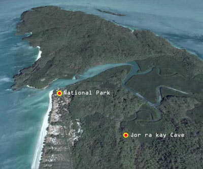
The 51 islands of the park archipelago lie in the Andaman Sea from 20-70 km.. off the extreme southwest coast of peninsular Thailand. Tarutao, the largest of the islands, is 26.5 km. long and 11 km. wide. The topography is mostly mountainous (highest point 708 m.) with a few broad plains and valleys. Semi-evergreen rain-forest blankets about 60 percent of the island, and pure mangrove swamps are found in several areas. Long sandy beaches lie along the western coast from Pante Bay to Makham Bay, and at Talo Udang Bay in the south.

Tarutao is a Malay work meaning old, mysterious and primitive. Preliminary geological work has borne out the first of these adjectives. Much of Tarutao is composed of very old Cambrian sandstone. The northern and southeastern portions of the island consist of limestone rock. Most of the caves on the island are formed in limestone rock.

The Adang-Rawi group of islands lies about 50 km.. west of Tarutao and includes Adang, Rawi, Dong and Lipe. Adang Island. with a steep and rugged landscape almost completely covered by tropical rainforest, may be the most wild and appealing of the islands. Sparkling clear water and superb coral reefs provide habitat for a wide variety of marine life forms, including many brightly colored fish. Beautiful beaches consist of quartz derived from Adang's Cretaceous granite makeup and coral fragmants. Several waterfalls plummet down Adang's eastern slopes in times of heavy rain.

Weather Condition

Tarutao and the west coast of peninsular Thailand are subject to a monsoon climate. In the summer months high temperatures in central China cause the air to rise, thus creating a massive low pressure area. This draws wind from the cooler area over the Indian Ocean. The winds coming off the Indian Ocean pick up moisture and dump heavy rains on the west coast of peninsular Thailand from May through October. Normally 250-400 mm. of rain falls in each of these months. The other six months of the year receive little or no rain. Total yearly rainfall averages about 2500 mm. The monsoon winds make boat travel dangerous from May through October; that is why visitors are encouraged to come to the park from November through April.

The mean yearly temperature is between 27 and 28 degrees C. The warmest month of the year is April, with the April mean about 29 degrees C. High temperatures in April may be 35 degrees C. or more. November and December are the coolest months of the year with mean temperatures of about 15 degrees C.

The mean yearly humidity is about 80%. It is highest in September, October and November and averages about 85%. Humidity is lowest in February and March, varying from 70-72%. The climatic data recorded here was not taken on Tarutao. It is based on data actually collected at Phuket and Trang, and is thus not completely accurate. But it is unlikely that the actual values for Tarutao would be much different.

In rainy season, the national park will be closed (Adang - Rawi Islands) during 16 May - 15 November every year for visitors safety.

Varieties of Plants and Wild Animals

For more extensive details on Tarutao National Park's natural resources, see the following publications in the library, but please do not remove them from the library.

Vegetation: The bioclimate of Tarutao is influenced by its position just north of the "Kangar-Pattani line" which approximates the transition from rain to monsoon forest. The change is due to decreasing rainfall and increasing seasonality in the climate northwards. Further complications of geology and azonal soil types create a mosaic of both Thai and Malayan forest species in the park. The dominant vegetation type in the park is moist evergreen forest. Other types are dry evergreen forest, mixed deciduous forest, mangrove forest, secondary forest and old agricultural land, beach forest, coconut plantation and scrub forest.

Wildlife: As is typical of island fauna, Tarutao National Park contains relatively few terrestrial vertebrates and resident birds, though visitors are still able to see wildlife. Dusky langurs, crab-eating macaques, mouse deer and wild pig are common on the islands. Due to prolonged isolation by sea, over 13 insular subspecies occur on the islands. There are at least nine insular subspecies of squirrels, five of common treeshrew and three of lesser mouse deer. Other wildlife occurring in the park are slow loris, otters, civets, flying lemurs, fishing cats, soft-shelled turtles, monitor lizards, pythons, cobras, coral snakes and vipers. Crocodiles may inhabit the saltwater swamps of Tarutao, but no sightings have been reported for several years. The feral cattle will soon be removed from Tarutao, and the rule against other domesticated animals is strictly enforced.

It is likely that over 100 bird species occur here, either as residents or migrants. The reef egret, which has both a light and dark color phase, is a commonly seen bird of both rocky and sandy coasts. Majestic white-bellied sea eagles and ospreys have been seen soaring over the park in their search for fish. There are three species of hornbills as well as more rarely encountered species such as frigate birds, dusky grey herons, pied imperial pigeons and masked finfoot. Just off the southwest tip of Tarutao is Ko Rang Nok (Birds' Nest Island) where a limestone cavern harbors a large colony of edible nest swiftlets; a shrine at the entrance was once used to make offerings of cattle skulls to placate the cave spirits and protect nest gatherers who scaled long bamboo poles to the cave's roof, a practice now prohibited

Marine Life: The area of Adang-Rawi contains many coral reefs of high species diversity. Degradation of some reefs by natural and man-made causes is significant but has not affected the overall ecological value of the park. The map insert shows some of the more interesting coral reefs in the park. The damage to some reefs are due to dynamite fishing, storm damage and crown-of-thorns starfish predation.

It is estimated that the park contains about 25% of the world's fish species. Some of the more important include members of families such as shark, ray, grouper, eel, carp, catfish, salmon, flying perch, angelfish and butterflyfish. 92 species of coral-reef fish were identified in one study.

Among marine mammals which can be spotted in the park are dugong, the common dolphin, the Irawadddy dolphin, sperm whale and minke whale.

Three species of migratory sea turtles nest on several of the island's beaches from September to April. Tragically, the present number of turtle nests may be less than a tenth of those found in 1974, a decline likely due to over-collection of eggs as well as mortality from fishing trawlers which often net adult turtles. Two American scientists studied the turtles during 1980-81, but their program of research and protection has largely been abandoned because of lack of manpower and funds.